resource
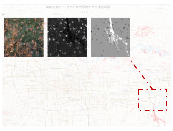
Optical SAR Change Detection Dataset of "7.20" rainstorm in Zhengzhou, Henan Province
This is a manually labeled dataset for optical and SAR image change detection.
publication
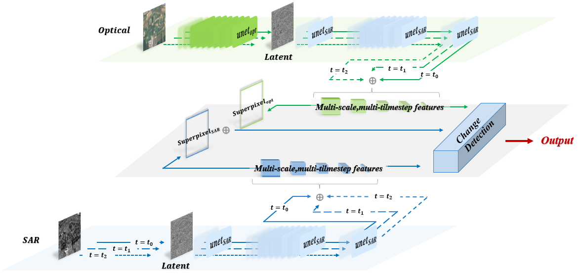
Diffpurifier: An Optical and SAR Image Change Detection Method Based on Diffusion Purification
Y.Xu, X.Su, L.Zhang
IEEE Transactions on Geoscience and Remote Sensing (TGRS) 2025.6
This article proposes a CD network for optical and SAR images, named Diffpurifier. First, optical images are translated into SAR images using pre-trained denoising diffusion probabilistic models (DDPMs) and ordinary differential equations (ODEs) while simultaneously extracting multiscale features. Then, CD is performed under superpixel enhancement to improve the homogeneity of the CD maps. Diffpurifier not only integrates IT and feature extraction, simplifying the workflow, but also maintains high accuracy, stable training, and generalization to different types of data without the need for additional translation constraints. In comparative experiments on four public datasets, Diffpurifier outperforms the second-best method by an average of approximately 5% in terms of F1 -score, validating the effectiveness and robustness of the method.
project
Land Cover Mapping and Updating for Long Time Series Remote Sensing Imagery
Guided by Associate Prof. Xin Su from Wuhan University
Jan. 2024 -- Present
Aiming at the problems of insufficient real label data, complex time-varying laws, and huge cross-sensor differences in the task of feature classification and mapping of long time-series remote sensing images, this project focuses on the research of “self-supervised pre-training model construction - explicit modeling of temporal characteristics - cross-sensor knowledge feature alignment”.
Theories of Video Remote Sensing Information Processing and Its Typical Geoscience Applications
Guided by Prof. Liangpei Zhang and Associate Prof. Xin Su from Wuhan University
Jan. 2023 -- Present
The key bottleneck issues that restrict the in-depth application of video remote sensing are insufficient information on complex and weak targets, insufficient mining of spatiotemporal variation characteristics, and unclear revelation of event evolution processes. Therefore, this project intends to systematically develop the theory and methods of video remote sensing information processing based on its characteristics of wide scene, high temporal sequence, and strong complementarity of temporal spatial information.